St. Ferdinand de Florissant Church
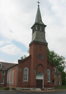
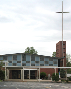
Genealogical DataThe following indexes/records from this congregation are available: Baptisms from 1765–1840 (These baptisms were first published in a St. Louis Genealogical Society book: Catholic Baptisms, St. Louis, Missouri, 1765–1840, (1998) Marriages from 1774–1840 (These marriages were first published in a St. Louis Genealogical Society book: Catholic Marriages, 1774–1840, 3rd edition, 1996.) HistoryEstablished 1789; still open The first church for this historic parish was built in 1789 on St. Dennis Street in Florissant. That site, about two acres, is now the Spanish Land Grant Park. The second St. Ferdinand church was opened in 1820 and is now the Old St. Ferdinand Shrine. St. Ferdinand was the focal point of the Catholic Indian mission movement of the 1800s with Father DeSmet and Mother Duchesne both active there. The Sisters of Loretto traveled from Kentucky to Florissant to staff the school in 1847, and the Jesuits oversaw St. Ferdinand Parish from 1823 to 1958, at which time the archdiocesan priests were assigned. The Old St. Ferdinand Shrine is today on the National Registry of Historic Places and contains exhibits outlining the history of the Catholic church in St. Louis. Because of large population growth, the third St. Ferdinand Church was erected in 1960. In 2018, the parishes of St. Ferdinand, St. Norbert, and St. Rose Duchesne created a partnership school called All Saints Academy-St. Ferdinand Campus. The records held by this church include registers for baptisms, first communions and confirmations, marriages, burials, and financial records of both Old St. Ferdinand (1789–1955) and New St. Ferdinand (beginning in 1955). Records are in Latin, French, and English. Address: 1765 Charbonier Road, Florissant, Missouri 63031 Telephone: 314-837-3165 Website (church): https://stferdinandstl.org/ Website (shrine): http://www.oldstferdinandshrine.org Location 1789–1820: St. Dennis Street, Florissant, Missouri 63031 GPS (Latitude, Longitude): 38.7970322, -90.333063 View Map Location 1820–1960: 1 Rue St. Francois, Florissant, Missouri 63031 GPS (Latitude, Longitude): @38.7964086, -90.3354489 View Map Location 1960–present: 1765 Charbonier Road, Florissant, Missouri 63031 GPS (Latitude, Longitude): @38.8069223, -90.356615 View Map |
|
The members of St. Ferdinand Catholic Church buried their dead first in a location near their church in a spot that is now a city park. That cemetery officially closed in 1873 and was replaced by a new cemetery about a mile away. That location is still open and is owned by the Catholic Archdiocese of St. Louis.
For access to the old St. Ferdinand cemetery, click here.
For access to the new St. Ferdinand cemetery, click here.
Last Modified: 29-Dec-2022 09:37