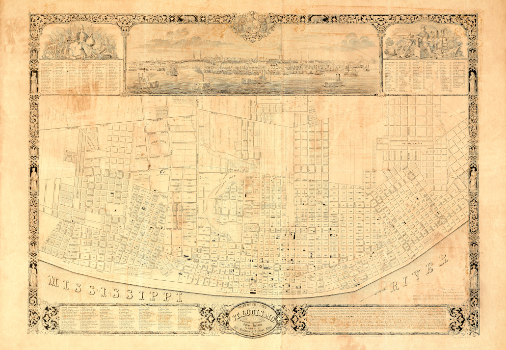
Hutawa’s 1850 Plan of the City of St. Louis, Mo.
Hutawa’s 1850 Plan of the City of St. Louis, Mo. was entered in the clerk’s office of the U.S. District Court of Missouri . . . 1842 by Julius Hutawa according to an Act of Congress respecting copyrights. Hutawa’s map included Steamboat Routes, 113 Points of Interest, and Notes which are reproduced below the map using the original spelling.
The map is available at the Missouri Historical Society
Georeferenced Map
Click on this image to see the map georeferenced in a Google Map interface with the points of interest annotated.
Steamboat Routes
| St. Louis to the Bar at South Pass Mississippi River. |
Fulton, Tenn. | 345 | Rodney | 878 | St. Louis to Pittsburg,Pa. | Mauckport | 513 | Point Pleasent | 714 | |||
| Randolph | 351 | Natchez | 918 | Mouth of the Ohio | 180 | Brandenburg Ky | 516 | Moscow | 718 | |||
| Greenock, Ark | 393 | Fort Adams | 974 | Trinity, III. | 186 | West Point | 534 | Mechanicsburg | 724 | |||
| Carondelet | 7 | Memphis, Tenn. | 409 | Red River | 936 | Caledonia | 194 | Portland & New Albany |
554 | Augusta Ky. | 731 | |
| Merrimac R. | 20 | St. Francis R. | 481 | Francisville La. | 1039 | Fort Massac | 217 | Levana & Dover | 733 | |||
| Herculaneum, Mo. | 32 | Helena, Ark. | 493 | Port Hickey | 1049 | Padacah (Tenn R) | 225 | Louisville | 558 | Ripley, O. | 736 | |
| Rush Island | 42 | Month of White R. | 563 | Baton Rouge | 1013 | Smithland (Cumberland R) | 237 | Westport, Ky. | 578 | Charleston, Ky. | 741 | |
| St. Genevieve, Mo. | 62 | Arkansas R. | 585 | Bayou Plaquemine | 1097 | Bethlehem, Ia. | 584 | Maysville & Aberdeen | 748 | |||
| Kaskaskia R. | 81 | Columbia, Ark. | 645 | Donaldsonville | 1128 | Tower Rock | 270 | New London | 590 | Manchester, O. | 759 | |
| Lacouse’s Is. | 96 | Point Chicot | 655 | Hampton’s | 1136 | Cave in Rock | 275 | Madison, la. | 597 | Vanceburg, Ky. | 775 | |
| Brainbridge Mo. & Hamburg, Ill. |
127 | Lakeport | 671 | Bringier’s | 1142 | Shawneetown | 296 | Port William, Ky | 611 | Alexandria, O | 793 | |
| Princeton, Miss. | 698 | Carrollton | 1211 | Raleigh, Ky. | 302 | Vevay and Ghent | 619 | Portsmouth | 795 | |||
| Cape Girardeau, Mo. | 137 | Bunch’s Cut-off | 709 | New Orleans | 1218 | Wabash R | 308 | Warsaw | 630 | Concord | 803 | |
| Mouth of the Ohio | 180 | Providence, La. | 729 | Poverty Point | 1256 | Carthage Ky. | 315 | Rising Sun, la. | 650 | Greenupsburg, Ky. | 815 | |
| Columbus, Ky. | 200 | Thompkinsville | 745 | Grand R | 1280 | Mount Vernon, la. | 328 | Petersburg | 660 | Burlington, O. | 838 | |
| Mills Point | 215 | Mouth of Yazoo R. | 790 | Ft.Jackson & St. Phillip | 1290 | Evansville la | 368 | Aurora la. | 662 | Gallipolis, O. | 880 | |
| New. Madrid, Mo. | 251 | Vicksburg, Miss. | 803 | Southwest Pass | 1310 | Owenboro Ky. | 404 | Lawrenceburg | 665 | Point Pleasent, Va. | 883 | |
| Riddle’s Point | 263 | Palmyra | 825 | Passa la Outre | 1313 | Troy | 432 | Cincinati | 689 | Setart’s Rapids | 913 | |
| Little Prairie | 289 | Big Black R. | 851 | Balice | 1318 | Cloverport, Ky. | 453 | Columbia | 697 | Belleville, Va. | 941 | |
| Needham’s Cut-off | 309 | Bruinsburg | 868 | Barat South Pass | 1322 | Fredonia, la. | 497 | New Richmond | 710 | Troy, O. | 946 |
| St. Louis to Pittsburg Pa | cont | Brownsville | 1111 | Louisiana | 108 | St. Louis to the Yellowstone Missouri River |
Marion | 176 | From St. Louis to | |||
| Blennerhasset’s Is | 958 | Cumberland | 1183 | Hannibal | 132 | Nashville | 185 | Independence | 371 | |||
| Parkersburg, Va. | 960 | Harper’s Ferry. | 1252 | Quincy, III. | 151 | St. Charles | 40 | Rocheport | 199 | Council Grove | 518 | |
| Vienna | 965 | Baltimore | 1332 | La Grange, Mo. | 163 | Washington | 80 | Boonville | 212 | Fort Mann | 728 | |
| Marietta, O. | 911 | Philadelphia | 1447 | Warsaw, III. | 187 | Newport | 88 | Arrow Rock | 227 | Santa Fe | 1147 | |
| Newport | 986 | New York | 1534 | Montebello | 199 | Griswold | 95 | Glasgow | 242 | From St. Louis to | ||
| Sistersville, Va. | 1013 | St.Louis to NewYork Via the Lakes |
Burlington, Iowa | 227 | Hermann | 113 | Grand River | 271 | Fort Bent | 934 | ||
| Wheeling | 1053 | New Boston | 265 | Gasconade | 118 | Lexington | 321 | Fort Hall | 1534 | |||
| Warren, O | 1062 | Chicago, III. | 341 | Rock Island | 315 | Portland | 128 | Camden | 335 | San Francisco | 2439 | |
| Wellsburg, Va. | 1068 | Detroit, Mich. | 1052 | Fort Armstrong | 316 | Osage R. | 149 | Liberty L | 365 | From St. Louis to | ||
| Steubenville, O. | 1075 | Buffalo | 1369 | Plum R. | 361 | Jefferson City | 159 | Independence L | 371 | Barat South Pass | 1322 | |
| Wellsville | 1095 | Albany | 1691 | Apple R. | 384 | Kansas R. | 386 | Chagress | 2772 | |||
| Georgetown, Pa. | 1102 | New York | 1836 | Fever R (Galena) | 399 | Platte R. | 396 | Panama | 2786 | |||
| Beaver | 1115 | St.Louis to St. Anthoni’s Falls |
Dubuque, Iowa | 419 | Ft. Leavenworth | 421 | San Francisco | 6286 | ||||
| Economy | 1127 | Cassville | 452 | Weston | 426 | From New York to | ||||||
| Middletown | 1135 | Missouri River | 17 | Wisconsin R. | 481 | St. Joseph | 471 | San Francisco via Cap Horn |
17000 | |||
| Pittsburg | 1145 | Alton III. | 23 | Prairie du Chien | 484 | Council Bluffs | 771 | |||||
| St.Louis to New York via Wheeling Va. |
Grafton | 37 | St.Anthony’s Falls | 860 | to Mandan | 1595 | ||||||
| Hamburg | 81 | to the Yellowstone | 1819 | |||||||||
| Wheeling | 1033 | Clarksville, Mo. | 96 |
Points Of Interest
| 1 German Methodist Church 2 Saints Peter & Paul Catholic Church 3 German Evangelical Church St. Paul 4 German Evangelical Church 5 Orphan Asylum (Sisters of Charity) 6 St. Vincent of Paul’s Church (Catholic) 7 Phoenix Engine House 8 Chapel (Sacred Heart of Jesus) 9 Convent (Seminary of the Sacred Heart) 10 Public School (Clark) 11 Wesley Chapel (Methodist Episcopal) 12 German Evangelical Lutheran Church 13 St. Mary’s Church (Catholic) 14 Medical College 15 Kemper College (Medical Department) |
16 Hospital (Sisters of Charity) 17 Public School (Laclede) 18 African Church 19 St. John’s Church (Episcopal) 20 Public School (2nd Ward) 21 Presbyterian Church (Spruce St.) 22 Washington Engine House 23 Medical College 24 German Protestant Church 25 Planters House 26 Centenary Church (Episcopal) 27 St. John’s Church (Catholic) 28 Laclede Engine House 29 Mississippi Valley Female Seminary 30 Concert Hall |
31 Scott’s Hotel 32 Wyman’s Hall 33 Central Engine House 34 Court House 35 Christ Church (Episcopal) 36 Jail 37 Post Office and Surveyor General’s Office 38 Planters House 39 Presbyterian Church (4th Ward) 40 St. John’s Church (Catholic) 41 Laclede Engine House 42 Mississippi Valley Female Seminary 43 Lithographic Establishment 44 Missouri Engine House |
45 Old Theater 46 New Theater 47 Unitarian Church 48 Glasgow House 49 St. Louis Engine House 50 Second Baptist Church 51 Odd Fellows Hall 52 Associate Reformed Church 53 Public School (4th Ward) 54 Presbyterian Church 55 St. George Episcopal Church 56 Central Presbyterian Church 57 School House 58 State Bank of Missouri 59 Planters Tobacco Warehouse |
|
| 60 Barnum’s City Hotel 61 Frederic House 62 Union Engine House 63 First Presbyterian Church 64 Ebenezer Chapel (Methodist Episcopal) 65 Free Presbyterian Church 66 Boatman’s Church 67 First Methodist Episcopal Church 68 Synagogue 69 State Tobacco Warehouse 70 African Church 71 St. Francis Xavier Church (Catholic) 72 St. Louis University 73 Medical College 74 African Church |
75 Virginia Hotel 76 Missouri Hotel 77 African Church 78 Liberty Engine House 79 Female Seminary 80 German Evangelical Lutheran Church 81 Western Presbyterian Church 82 Corinthian Hall 83 St. Paul’s Church (Episcopal) 84 Presbyterian Church 85 Methodist Protestant Church 86 German Methodist Church 87 Engine House 88 Public School House 89 German Evangelical Church |
90 St. Patrick’s Church (Catholic) 91 Orphan Asylum (Sisters of Charity) 92 Biddle’s Monument 93 St. Joseph’s Church (Catholic) 94 Old Reservoir 95 Waterworks 96 Kennett’s Shot Tower 97 Mound Engine House 98 Public School (6th Ward) 99 North Presbyterian Church 101 Methodist Church 102 Orphans’ Home (Episcopal) 103 Grace Church (Episcopal) 104 German Methodist Church |
||
| 1a Urselin Convent | 3a St. Louis Cotton Factory | 6a Public Schoolhouse | 47a Presbyterian Pine St. Church | |
| 50a 1st Congregational Church (Unitarian) | 36a German Emigration Society | 35a Republican Office | 43a Reveilie Office | 49a St. Louis Union Office |
Notes
NOTE. St. Louis, Mo. bounded North by Rocky branch, East by the, Mississippi, South by westline touching the Arsenal tract and West by a line along the westseide of Second Carondelet Avenue to an intersection with Chouteau Avenue, thence in a straight line the mouth of said Rocky branch, the point of beginning, as incorporated under the amending Ad of the General Assembly of the State of Missouri approved the 15th February 1841. All the numerous Additions to the City since the first establishment thereof; are correctly copied from the liles of the Recorder of the County of St Louis and connected, in taking as a basis the Original Survey’s filed in the U.S. Surveyors Office for the district of Illinois and. Missouri The first plan of St. Louis, under the name of St. Louis des Illinois, was made according to an order of government in 1764; the town was fortified by Lieutenant governor Francois de Crusat in 1180 and a plat thereof, shows all the ancient denominations of st reels. public squarsund fortifications. It calls for instance. Main street, Grande rue; Second St Rue del’lglice; Third St. Ruc des Granges; it calls Walnut St. Rue de In Tour: Marliet St. Rue de la place; Chesuut St. Rue Missouri, A; Pine St. Rue quicapou, B; Olive St. C, Locust St is called D; and soforth, lettering the Streets up to Oak, now Morgan Street which is designated with the letter // showing a Bustion, halfmoon, and u tower along the place of the present Cherry Street,(vix 1st Eddition of this map). Another plat of the torntt of St Louis showing Is boundaries usli red by the Court of Common Pleas, in November term of’ 1809 as bounded north by an cast and west line passing a point the northern peripherie of Roy’s tower, situated neur Hiddle Street on the bank of the Mississippi river_extending mest to the western line of the Common Field of St. Louis, and thence southward and cast to the Sugar louf. A Third plat of the City appeared under Bene Pant, comprising that purt of the City which mas chartered® the 9th December 1822 bounded by Seventh Street by an east line through the northern side of Roy’s tower, the middle of main channel of the Mississippi River and a west line passing the bridge on Second Street over Chouteau Mill Creek All these maps mere of little use to the Public in generul, until “” counceled map of the City appeared in 1840 our First Eddition By constructing the present map, the 7th Eddion, all the above plans and Diagrams have been taken as a foundation and thayand the most accurat general net of the Spanish Surveys have given the test lines whereinto the numerous additions to our City have been platted and connected with the greatest care – tested particularly by the latest Surveys – The Population of St Louis mas in the Year 1810, 1600 – 1820, 4598 – 1830, 6694 – 1840, 16469 in 1850 near 70,000.