In order to see all the plats on this atlas, you will need to zoom into the map.
Do so by using the scroll wheel on your mouse.
Alternatively, you can click on the plus/minus icons on the upper left of the map.
The satellite atlas map view can be rotated by:
Selecting the satellite view , selecting the 3D view , Rotating the image left or right
The opacity of the overlay can be adjusted with slider in the lower left corner
Other atlas pages with Maps will be outlined in red
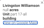
Clicking on the atlas points will bring up info on that map
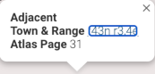
Single clicking on the atlas polygons will bring up info on that atlas page
To get the coordinates of any point you can right-click to get an info bubble which has a Google Maps link .
Clicking the little broken square in the upper right of the map enters full screen, which will also enlarge the map.
To exit the full screen, just press the Escape (ESC) key on the upper far left of your keyboard.
To move to the current GPS location of your laptop or phone you can click on the arrow icon . You will be asked initially to allow the interface to use your GPS location.
.
Property Points Forthcoming means the property points have not been collected yet.
 , selecting the 3D view
  , Rotating the image left or right

 .
. . You will be asked initially to allow the interface to use your GPS location.