In order to see the congregation locations, you will need to zoom into the map.
Do so by using the scroll wheel on your mouse.
Alternatively, you can click on the plus/minus icons on the upper left of the map.
The satellite map view can be rotated by:
Selecting the satellite view , selecting the 3D view , Rotating the image left or right
The clickable link to the St Louis Genealogical Society page with the full list of congregrations is at the top left
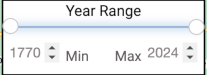
The range of the years that the congregations have been opened can be modified with the control in the lower left corner
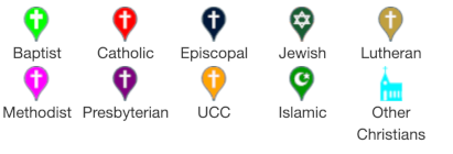
Clicking on the congregation icons will bring up info on that congregation
To get the coordinates of any point you can right-click to get an info bubble which has a Google Maps link .
Clicking the little broken square in the upper right of the map enters full screen, which will also enlarge the map.
To exit the full screen, just press the Escape (ESC) key on the upper far left of your keyboard.
To move to the current GPS location of your laptop or phone you can click on the arrow icon . You will be asked initially to allow the interface to use your GPS location.
.
 , selecting the 3D view
  , Rotating the image left or right

 .
. . You will be asked initially to allow the interface to use your GPS location.