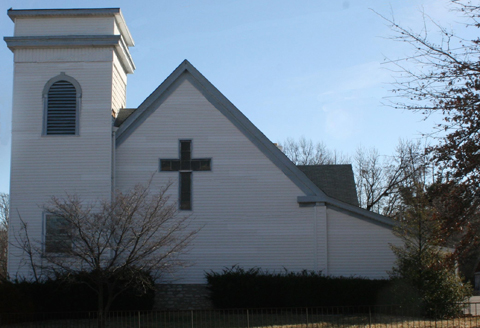
St. Jacobi Lutheran Church
|
(LCMS—Lutheran Church Missouri Synod) Genealogical DataThe following indexes and/or records from this congregation are available: Confirmations from 1907 to 1938 Deaths recorded from 1907 to 1974 StLGS is following state guidelines for privacy wherever possible. Births/baptisms online must be at least one hundred years old; confirmations eighty-six years old; marriages forty-five years old; and deaths fifty years old. Additional indexed data from these records may be available; please come to the StLGS office to view it. As privacy limits permit, society volunteers will post additional data online. |
|
History
Established: 1906; closed: 2011
St. Jacobi Evangelical Lutheran Church began as a new mission church on 17 July 1906, when members of Ebenezer, Grace, and Bethlehem Lutheran churches in St. Louis joined to establish a new congregation for the growing population in north St. Louis County. Church services were held in the home of Henry Gehner, president of the new congregation, until 28 October, when the cornerstone of the church was laid. By then the congregation was too large to be held in a home, so they rented the Methodist chapel on Hord Avenue in December 1906. At this time, Rev. Emil M. Biegener, from Rader, Missouri, began to serve as first pastor.
The new church/school held a dedication ceremony on 24 February 1907. Morning services were in German and on Sunday evenings, services were held in English. By 1907, they made plans to build a parsonage on the east side of the church. The church itself was rebuilt in 1922. The congregation continued to grow, necessitating a new school in 1954. However, by the early 1980s, the neighborhood had grown older and many of the congregants had moved away. With a very small congregation left, the church eventually closed its doors.
Address: 8646 Jennings Station Road, Jennings, Missouri 63136
GPS (Latitude, Longitude): 38.720935, -90.256982 View Map
Property sold in 2011.
Last Modified:
07-Nov-2024 15:50